 |
|
|
A Road to Nowhere Leads To Submerged Memories
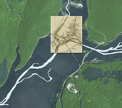
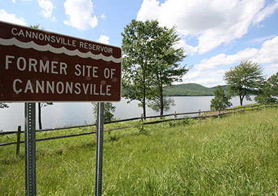
It was 1963 and “The Taking” of Cannonsville was nearly complete. 124 years after his death, Benjamin Cannon, founder of this community, literally rolled in his grave. Just a few years earlier it was a picturesque setting. Nine miles east of the Town of Deposit State Route 10 branched off to the west and descended into a valley. There, nestled between foothills at the confluence of Trout Creek and the western branch of the Delaware River was a small farming community known as Cannonsville. The old Cannon homestead was on River Street. Built in 1790 by the town’s namesake, it had five stone fireplaces and stood as Cannonsville’s oldest landmark. A large dairy farm and creamery was just up the road. Spanning the river a twin-arch steel bridge led into town. A war memorial was on the left, and up Main Street was the old Community House, Adams general store and a barber shop. There were three churches in town, two schools, three taverns, a cemetery, and a century-old covered bridge. Eminent domain is defined as "the right of a government to take private property for public use by virtue of the superior dominion of the sovereign power over all lands within its jurisdiction.” In this case, the sovereign power had an ambitious plan to dam up the valley and create a large reservoir to provide drinking water to New York City. Known as the Cannonsville Reservoir Project, local residents had their own term for it… “The Taking.” “They were talking about it in the 1940’s,” said former Cannonsville and Rockroyal resident Helen Schriver-Zandt, “then in the 50’s it got serious – that’s when they came in and started buying properties.” 74-year old Zandt remembers hearing locals talk about “the damn dam” as a child. Finally, in 1964 the last residents were driven from their homes, the dam was completed and water began to rise.
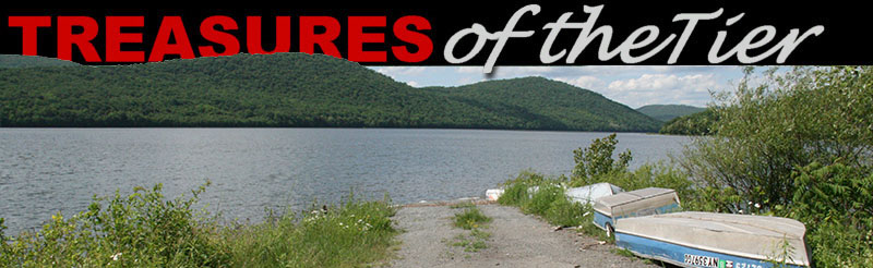
Not far from Benjamin Cannon’s homestead, water enters a tunnel to begin a 120-mile journey, eventually combining with water from other reservoirs and ultimately passing below the Hudson River before reaching kitchen faucets in the Big Apple. Cannonsville is just one of five small hamlets eliminated by the reservoir, others being Rockroyal, Granton, Rock Rift, and Beerston. Nearly 20,000 acres of land were taken for the Cannonsville Reservoir project. 941 residents were displaced and 2,150 graves from eleven cemeteries were relocated to a variety of cemeteries in the region. Founder Benjamin Cannon’s remains were reinterred in the Pepacton Cemetery, 40 miles from his home and original gravesite. In 2007 Zandt published a book about the experience. Titled “Memories,” the book is a compilation of photographs, articles and recollections of former residents forced to leave their homes. The area still harbors strong feelings about New York City and The Taking. “We have no use for them,” Zandt said, speaking of those who took possession of their property and flooded their homeland. “They were not nice people,” she said. “Even though the farmers in these communities all banded together, they were no match for [the City].” A few structures survived the project and can be seen today. The war memorial was relocated to Speedwell Mountain above the water line overlooking the spot where Cannonsville lies submerged. The 1850 covered bridge was removed to Unadilla, then after reconstruction following a fire it was moved to its current home in Old Mill Village, New Millford, Pennsylvania. A few of the newer homes were relocated prior to flooding the valley, said Zandt, who remembers standing guard in her home until the day it was hauled to its new location in a nearby town. Annual reunions of residents displaced by the reservoir have been held for decades. Zandt said the early events attracted nearly 500 people but the number has gone down over the years. This year she expects one hundred to attend when the reunion takes place July 28 at the Firemen’s Pavilion in Deposit. Today, nine miles east of Deposit on State Route 10 the setting is that of a picture postcard. Eagles soar in thermals overhead, forested mountains and foothills stretch as far as the eye can see, and a placid 16-mile-long lake mirrors the blue sky. A handful of small non-motorized rowboats can be seen on the water where fishermen experience the quiet pleasures of this pristine treasure in the Catskills. There is nothing to indicate that this picturesque scene is anything other than pure, unadulterated nature. There are no clues to what lies 75 feet below the rowboats in dark submerged silence – roads untraveled for half a century, stone outlines of 200-year-old homesteads – of the Community House, Peg’s Tavern, and scores of other former structures. Below the rowboats once-sacred sites lie dormant, long since stripped of graves and headstones. A twin-arch steel bridge leads to a sunken ghost town where nine generations of residents lived and worked, and before that, unknown generations of American Indians called the confluence of these rivers home. Truth be known, there is one clue to the existence of this secret world that can still be found. It is a road that branches off State Route 10 to the west. That same road that led to Cannonsville fifty years ago is still there, but now it slips beneath the gentle waves and quickly disappears from sight. Watch for it when driving up Route 10, but when you come to the fork in the road, do not, as the saying goes, “TAKE IT.” The City of New York already did.
|